Mcleodganj to Dharamshala Trek is an exciting way to travel between the two towns. A walk in the cool Himalayan Mountains and Forests is more enjoyable than travelling via road in a cramped share-a-taxi or bus. The trek route from Heeru Village to Yaru Village (both in Mcleoadganj) to Gamru Village (Dharamshala) is detailed below.

Mcleodganj To Dharamshala Trek Route, Directions, Map
1] STARTING POINT: Heeru Village, Mcleodganj (off Bhagsunag Road); alternate route is near Pink Hotel on Jogiwara Road
2] LANDMARK 1: Yaru village (sometime also called Heeru Village)
3] LANDMARK 2: Gamru Village with a large circular water tank
4] ENDING POINT: Kotwali Bazaar (Main Market) in Dharamshala
MCLEODGANJ TO DHARAMSHALA TREK DISTANCE: 3.5 KM
TREK TIME: 1.5 Hours (Fast Pace) to 2.5 Hours (Easy Stroll)
DIFFICULTY LEVEL: Easy.
TREK TERRAIN: Start and end is along Tar and Cemented Roads. Middle section is a Rocky Mountain trail going through forest and villages.
Mcleodganj To Dharamshala Trek Map (Heeru, Yaru, Gamru)
Mcleodganj To Dharamshala Trek Route Details
1] MAIN SQUARE MCLEODGANJ TO HEERU VILLAGE SCHOOL
- The small Mcleodganj Square is centrally located and is the starting point of the Mcleodganj to Dharamshala Trek.
- Walk East along the Bhagsunag Road. This road goes to the famous “Bhagsu Nag” Temple and Bhagsu Waterfalls.
- 300 Meters from Mcleodganj Square there is a winding road on the right. Take this cement road on the right. Walk downhill for 350 Meters until it reaches the Heeru Village School. The cement road ends here and from now-on the trek is along village and mountain trails.
- The Heeru Village School is brightly coloured and a prominent landmark.
")
ALTERNATE STARTING POINT: IGNOU AND PINK HOUSE (JOGIWARA ROAD)
- From the Mcleodganj town square walk towards the Jogiwara Road. 450 meters from the town square there is steep downhill staircase on the left. IGNOU (Indira Gandhi National Open University, Yongling IGNOU Special Studies Centre) and Pink Hotel are the Landmarks.
- After reaching the bottom of the 200 steps (approx.), turn right and walk towards Yaru Village (sometimes also called Heeru).

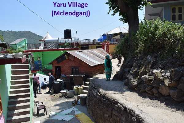
2] HEERU VILLAGE TO YARU VILLAGE (MCLEODGANJ)

- Looking down from Heeru Village one can see Mcleodganj town on the right, Yaru Village, Gamru Village (Dharamshala), the “Souli Khad” River/Stream valley, Kangra Valley in the distance and Indrunag (on the left).
- There is a clear path on the right which leads to a small bridge. Cross the bridge and continue on the path to Yaru Village. (Please refer to the above image).
- NOTE: Sometimes “Yaru” Village is called “Heeru” Village on Google Maps. The “Urban Camp Mcleodganj” states its address as Heeru Village. Locals call this village Yaru and not Heeru. As long as you are travelling South in the direction of Dharamshala you should be fine.
- Distance between Yaru and Heeru is approximately 400 Meters.
3] YARU (MCLEOD) TO WATER TANK AT GAMRU (DHARAMSHALA)


- From Yaru (Mcleod ganj) to Gamru (Dharamsala) the trek is along a rough mountain trail. It passes through woods of “Dhauladhar” trees (Himalayan Cedar).
- At the end of the Yaru Village is a water tap. You may want to wash up and drink a little water before starting on the mountain track. Walk in the South, downhill direction towards Dharamshala.
- Below on the left is the “Souli Khad” river/stream and up on the right is the Jogiwara Road that connects Mcleodganj and Dharamsala. All around is the amazing beauty of the Indian Himalayas that makes Mcleodganj such a popular tourist destination. Trekkers will be tempted to halt on this path and admire the amazing beauty all around.
- As you approach Gamru village, you will see a large, white, cylindrical water tank on the right. Please see the image of the Gamru Water Tank. Many years ago the green fields near the Water Tank had houses, which were wiped away by landslides.
- Distance between Yaru and Gamru is approximately 800 Meters.

4] GAMRU VILLAGE (DHARAMSALA) TO KOTWALI BAZAAR

- With the approach of Gamru Village, the coarse mountain track is converted into a cemented path. The first area with habitation is known as “Couple Court”.
- As shown in the above Gamru picture, there is a fork in the road. The straight road downhill goes through Gamru village and eventually leads to Kotwali Bazaar in Dharamshala.
- The cemented road on the right goes through another part of Gamru Village and eventually meets up with Sessions Road (Jogibara Road), near the “Shree Om Kareshwar Mahadev Mandir” (Lord Shiva and Ganesh are the deities). Kotwali Bazar, Dharamshala is a short walk from here. Landmarks on this route are the Gamru Village School (please see the below image) and the Lord Shiva Temple.
- Distance between Gamru Village and Kotwali Bazaar is approximately 1,500 Meters.

To travel from Dharamshala to Mcleodganj there are government/private Buses (from the Bus Stand), Share-A-Taxi (near the Bus Stand and Kotwali Bazar) and Private White Taxis.

Mcleodganj to Dharamshala Trek: Caution, Tips
CAUTION:
- During the monsoon this trail becomes muddy and it can be messy walking along this trail. Expect to see snails, mosquitoes, frogs and similar insects, reptiles and animals.
- There are one or two places where the trail is a little challenging. This is more so during the monsoon. A little thought and patience will help at these tricky places.
- There are fruit bearing trees that attract animals. There are local trees where the black fruits grow from June. Bears from forest around Mcleodganj are attracted by these fruits. It is not uncommon to see a bear sitting in a tree, enjoying its fruits.
- The thin leaves of the Himalayan Cedar tree (called “Dhauladhar”) shed a lot and are all over the place. These thin Cedar leaves are slippery. Since these leaves are all along the forest path, tread on them carefully.
TIPS:
- Wear comfortable hiking shoes. Avoid slippers and sandals.
- Wear full pants. This will prevent/reduce thorn scratches and insect bites. Avoid shorts, skirts, etc.
- Carry water and stay hydrated. Pack a small snack.
- Carry a mobile and use Google Maps to track your progress towards Dharamshala. Note that this trail is not shown on Google Maps; but the map will show whether you are travelling in the general direction of Dharamshala (towards the South).
- The main road in Mcleodganj leads from the town square (at the entrance of town) to the Dalai Lama’s Temple. This is a mountain ridge (narrow elevated mountain surface) which ends at the Hill with the Dalai Lama’s House. On both sides of Mcleodganj there are wonderful mountainous forest treks that go south to Dharamshala. The Heeru Village to Yaru Village (both in Mcleoadganj) to Gamru Village (Dharamshala) is one such Mcleodganj to Dharamshala Trek.