The route of the Mcleodganj Monastery Trek is from Mcleodganj to Tsechokling Monastery to Dharamshala. Large part of the Mcleodganj Monastery Trek is through the mountain forests of Mcleodganj and Dharamshala.
NOTE: This trek can also be done in the reverse direction (from Dharamsala to Mcleodganj). Follow the instructions in reverse.
Mcleodganj Monastery Trek Route, Directions, Map
1] STARTING POINT: Mcleodganj Main Square
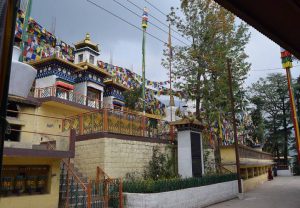
2] LANDMARK 1: Tsechokling Monastery in the forests of Mcleodganj
3] LANDMARK 2: Dharamsala Community Meditation Centre
4] ENDING POINT: Kotwali Bazaar, Dharamshala
TREK DISTANCE: 2.8 Km (Google Map shows 2.2 Km, but the forest paths are longer)
TIME: 1.15 Hours (Quick Walk, without stopping at the Monastery), 2.15 Hours (Easy Stroll)
DIFFICULTY LEVEL: Easy
TREK TERRAIN: Downhill Forest Trail, village road and cemented steps
Mcleodganj To Dharamsala Tsechokling Monastery Trek Map
This is the map of the Mcleodganj Monastery Trek from Mcleod ganj to Dharamshala via Tsechokling Monastery and Dharamshala Community Meditation Center.
Mcleodganj Monastery Trek Route Direction and Pictures
1] MAIN SQUARE MCLEODGANJ TO TSECHOKLING MONASTERY

- Stand at Mcleodganj square with your back to the bus stand (entry point to Mcleodganj) and eyes facing the famous “Kalachakra Temple”. You will see Pastry/Bakery shops.
- The right-most road is a small lane to the right of “The Pastry Shop”. “Nowrojee & Son” shop leads up to this road. The road is wide enough for motorcycles and scooters, but not for cars and trucks. This road leads to Tsechokling Monastery.
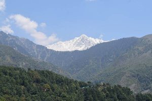
- As you walk along this road, you can see Kangra Valley in the distance.
- After 200 Meters the road ends is a series of concrete, downhill steps to the right. (Please refer to the below image). This path of stairs is approximately 250 Meters and it goes from Mcleodganj to Tsechokling Monastery.


2] TSECHOKLING MONASTERY TO DHARAMSALA MEDITATION CENTRE

- Tsechokling (Tse-Chok-Ling) is a Tibetan Monastery nestled in the forests of Mcleodganj. At the heart of the monastery is a Tibetan Buddhist Temple, which was inaugurated by the Dalai Lama in 1987. In addition to the Buddhist Temple, Tsechokling Monastery also has residences for monks, classrooms, dining hall, office, staff quarters and more.
- Standing at the main Tsechokling Temple entrance, turn your back to the temple and walk straight in the Southern direction towards Dharamshala. You will pass the Tsechokling Monastery Office. The last monastery building that you pass will have a nameplate stating “Yellow House”. In all probability it will be painted yellow.
- Alternately, when you walk down from Mcleod and you reach the gate of Tsechokling Monastery, do not walk down to the Temple, but take the path on the left which will lead to “Yellow House”.
- Tsechokling Monastery has toilets and water. This is a good spot to get refreshed.

- The forest path starts at the end of Tsechokling Monastery. This downhill forest trail leads in the South direction towards Dharamshala.
- When you look up on the left, you will see the white canopies of the Dalai Lama’s Temple. Use this as a benchmark.
- At some places there will be two trails. The left pathways usually end up on the mountain, near the Dalai Lama’s Temple. Keep going on the downhill southern path.
- There is no habitation on this pathway, only the mountain forests of Mcleodganj and Dharamshala.
- The next landmark is the Dharamsala Community Meditation Centre. The Meditation Center is approximately 900 Meters (779 on Google Maps) from Tse-Chok-Ling Monastery. A series of small cottages houses the Meditation Center. The folks at the Dharamshala Community Meditation Center keep a pot of water for tired passerby (please see the below image). This writer is thankful to the Meditation Centre for providing a cool, refreshing drink of water.

3] DHARAMSHALA CENTRE TO JOGIWARA ROAD TO DHARAMSALA

- Continue in the South direction from the Dharamshala Community Meditation Center. At this point too the trek is along a forest pathway.
- 600 Meters (490 on Google Maps), the forest trail ends in a concrete road. This is the “Narojee Road” in Upmuhal (Dharamshala). Among the first structures you will see is “Clouds End Villa”, which is the residence of the Raja of Lambagraon (Kangra).
- Next on the “Nowrojee Road” is a village in Upmuhal, Dharamshala. (Please refer to the above image). Up on the hill is the building of the famous Tibetan Traditional Medicine Clinic.
- Continue along this concrete village road until you come to a fork in the main road. (Please refer to the below image). This is the Jogiwara (or Jogibara) road that connects Dharamshala and Mcleodganj. The road on the left goes to Mcleod Ganj and the winding road on the right leads to Dharamshala. Take the road to the right.

- 30 meters from the fork in the Jogibara Road there are three roads. All three roads lead to Dharamshala. The straight road is a one way road for vehicles coming from Dharamsala. This road is open for pedestrians. On taking a “U” turn, there are two roads. The first is a pedestrian footpath which passes the Himachal Pradesh High Court Guest House and houses of serving judges of the HP High Court. For this trek we take this road. The last road after the “U” turn is a vehicle road that goes to Dharamshala. (Please refer to the above Map).
- The concrete pathway that runs along the HP High Court Guest House passes by the houses of senior government officials. After a while the concrete road turns into a rough trail (not shown on Google Maps). Continue on this path until you reach a concrete road. This area is “Loharkadi Upper Sudher” and you will be able to see “Kotwali Bazaar” from here. Follow this road until you reach “Kotwali Bazar”, Dharamshala.

To return from Dharamshala, trekkers can take a share-a-taxi from either here or near the Dharamshala bus stand. Trekkers can also take a bus to Mcleodganj from the Dharamshala Bus Stand.